Minecraft shoved the whole UK
It turns out that in the State of ordnance survey of great Britain (Ordnance Survey) also have fans of the game Minecraft. To demonstrate what can be done with open map data they have carried out great experiment and imported into the game world the entire country.
22 billion Minecraft blocks correspond to more than 220 000 km2 the UK and surrounding Islands. The map did not hit Northern Ireland, because of its cartographic survey engaged in another organization.
To repeat the experiment of the State mapping service of great Britain can each developer, using the open datasets and instrumentami.
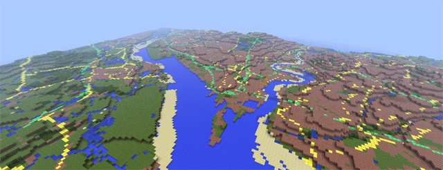
The import program processes a Minecraft maps in areas of 100x100 km, for each load information on the height of land above sea level from the base of OS Terrain 50, then loaded the raster images with maps OS VectorMap District. Color each square of 20x20 pixels is determined by what material the unit should be Minecraft. For example, the roads were made of emeralds, pumpkins and gold coastline — sand, forest — leaves, meadow — grass, urban development — of the bricks, the water — from the water.
Each block corresponds to an area of about 50 m2.
You'll need 5 GB of free disk space and 4 GB of RAM, the size of the world in the form of decompressed is a 3.6 GB. Archive with cubic Kingdom is 345 MB: Minecraft-GB.zip.
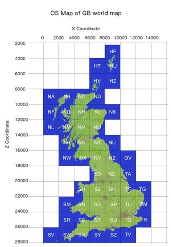
If you want, in this world you can try to find familiar places. Here in-game coordinates of some sites:
the
Port of Southampton ----------------------- X = 9000 Y = 100 Z = 26000
London ---------------------------------- X = 10632 Y = 100 Z = 24422
Mount Snowdon ---------------------------- X = 5218 Y = 200 Z = 20913
West island ------------------------ X = 2110, Y = 100, Z = 10000
Shetland Islands --------------------- X = 8900, Y = 100 Z = 4969
The Harbour Pool ----------------------------- X = 8020 Y = 100 Z = 26235
Weymouth ---------------------------------- X = 7300 Y = 100 Z = 26440
The island of Foulness in Essex ---------------- X = 12000 Y = 100 Z = 24174
Lake Windermere ------------------------- X = 6800 Y = 100 Z = 18080
The government mapping service - X = 8745 Y = 100 Z = 25695
The diagram below will help to determine the coordinates of each location.
the rest of the UK in Minecraft


Комментарии
Отправить комментарий